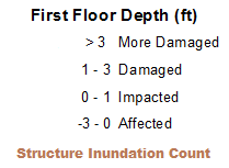
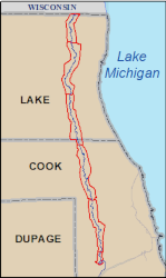
IDNR Office of Water Resources maps the floodplain inundation produced by the National Weather Service river gauge stage by utilizing existing hydraulic model profiles and IDNR topographic elevation models based on LiDAR bare earth. Six river gauges are present for the Upper Des Plaines River: Riverside, River Forest, Des Plaines, Lincolnshire, Gurnee, and Russell. Inundation libraries based on stage readings at each gauge have been created and shown within the mapped area for each gauge.
The levee protected areas have been mapped for inundation without regard to the protection of the levees.
The Upper Des Plaines River Stage Inundation Mapping Project was completed in cooperation with the US Army Corps of Engineers, Lake County Government and IDNR Office of Water Resources.
The Illinois Department of Natural Resources, State of Illinois, US Army Corps of Engineers and Lake County Government make no guarantee, expressed or implied,
regarding the accuracy of the data. The Illinois Department of Natural Resources, State of Illinois, US Army Corps of Engineers and Lake County Government shall not be liable for any activity involving this data with regard to lost profits or savings or any other consequential damages; or the fitness for use of the data for a particular purpose; or the installation of the data, its use, or the results obtained.
CLOSE
An ArcGIS Viewer produced by DNR Office of Water Resources
The Illinois Department of Natural Resources, State of Illinois, US Army Corps of Engineers and Lake County Government make no guarantee, expressed or implied,
regarding the accuracy of the data. The Illinois Department of Natural Resources, State of Illinois, US Army Corps of Engineers and Lake County Government shall not be liable for any activity involving this data with regard to lost profits or savings or any other consequential damages; or the fitness for use of the data for a particular purpose; or the installation of the data, its use, or the results obtained.
The levee protected areas have been mapped for inundation without regard to the protection of the levees.
If you understand and accept this disclaimer, click on the agree button.